How to Climb the Wrong Ridge

During one of our days camping up at Lower Boy Scout Lake (trip photos of the main trip can be found here), Terri and I took a day hike to Upper Boy Scout Lake and I was sort of hoping I'd have time to climb Mt Carillon and get a glimpse of Tulainyo Lake which hides behind it.  Well it turns out, I climbed up the wrong ridge because Mt Carillon looks vastly different from the side I was viewing it versus the side where its picture is commonly taken.

(Click on any photo to see a larger version.)


This is the route that I should have gone up (image located at:
http://www.summitpost.org/image/16426/when-you-see-this-view-turn.html

But instead I was thinking that the tall portion was somehow a part of Mt. Russell,
even though I had seen Russell from Upper Boy Scout Lake (and knew of the distance
between them), so I instead veered off to the right.  Oops.


There were a couple of reasons for this.  For one, the batteries in my GPS had died and since I was determined that this was just a fun little side trip and not a major goal, I didn't bring spares.  For another, the photos of Carillon that I had seen looked nothing like the left photo below. The problem is that the view of the route is 90 degrees rotated from the photos of the mountain itself.  In the photos below, I've circled in pink the same feature as viewed from both angles (I figured this out in the comfort and lower elevation of my house and not on the mountain.)


I didn't know how off I was until I got to the top of the ridge and looked over and didn't see Tulainyo Lake but instead a wash that I knew was one gorge to the right of it.   As the weather was worsening, and over the radio Terri said that she was getting worried about the clouds rolling in, I started to head down (After taking the batteries out of the camera long enough so that I could turn on the GPS and get a way point for later study.

Notes

The approach is a scree slope, but if you're of average weight and strength then it's usually not a problem.  Just don't waste your energy fighting the slight sliding back as long as it's safe.  Think of it as a zen exercise if you will.

If you're serious about climbing a particular mountain, bring extra batteries for the GPS! (Lithium recommended as they are lighter and more temperature tolerant and last longer), and bring a compass to use if all else fails, and this is of course assuming that you have a map.

Random GPS notes:  When routefinding it's easier to work with UTM coordinates that Latitude/Longitude as the UTM ones show up at more frequent intervals on the average topo map.  And if you make much use of topo maps, I highly recommend the Topo! software.  Also, Geocaching might seem like a complete waste of time, but it's a great way to learn how to use the basics of your GPS.

Some other photos


As I was climing and trying to decide which way was up I was veering off to the right, but some deer were in the way of the way that I was thinking I should go (pink circle - click for larger versions).  Since I didn't want to bug them (though they appeared to be getting quite a bit of amusement watching me), and I wasn't sure if that was the correct way any way, I left them alone and stayed to the left of them which kept me from going even further off course.

Earlier in the hike...


The approach to Upper Boy Scout Lake via the North Fork of Lone Pine Creek
(the greenery from the lower center of the photo going off to the left.)

Upper Boy Scout Lake

Upper Boy Scount Lake and Mt. Russell in the furthestmost background

View to the right of Mt Carillon where I ended up
(the deer are somewhere on the far right.)
Picturesque view even further to the right of the deer.

Despite (or because of) being in the wrong location, the climbing has its own set of challenges as there was some exposure in places.

The view from the top of the ridge looking South-West.
If I were more industrious, I'd join the photos in Photoshop or other tool, but not right now.
That peak in the distance is Lone Pine Peak.


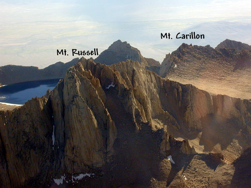
Another great photo of Mt. Carillon, Mt. Russell (for the real mountaineers) and
Tulainyo Lake in the background (obviously I didn't take this one).
This photo can be found at:
http://www.summitpost.org/image/16425/mt-russell-and-mt-carillon.html


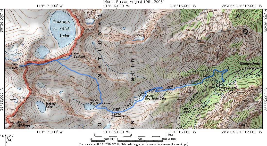
The route I should have taken
Photo is from:
http://www-db.stanford.edu/~crespo/Pictures/Russell03/RussellMapT.jpg

"Ridgetop" is where I ended up. 
I haven't drawn in a path as it would look like a drunken sailor.
I've labeled the rocky outcrop that I should have headed towards "Pinnacle"